
Maps of Earth.
The most familiar maps are by no doubt the various maps of Planet Earth, first lets take look at the Globe:

It is clear that the representation of planet earth on the Globe follows our two rules for a MAP. For example, England and France take different areas on the Globe (second rule); Siberia and Alaska appear adjacent on the Globe (First rule). Is the Globe the only valid map of earth? No, an example for an alternative map that satisfies our 2 requirements is a cube as we can see from the following map of Earth:
 Here are some more maps of Earth on other solids:
Note that we do not claim that the shape of planet earth is a cube, we claim only that a cube could take a valid representation of planet earth.
When we will examine configuration spaces of machines, there will also be no unique mapping to a unique shape. Below, are two more examples of mappings for the configuration space of the one-leg machine. Notice how the mappings to the hexagon and the ellipse follow our two rules and are therefore valid representations of the 1-leg machine's configuration space.
We find it more convenient to look on flat maps of earth since it is possible to place them in geographical books and on our monitor's screen. Here is an example of such a map:
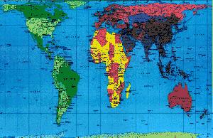
| Does this earth map follow our 2 rules for a valid map? On the map Alaska and Siberia appear very "far" while in reality these areas are adjacent, therefore this map is not a valid representation by our standards. In reality when we study this kind of earth maps, we accept the fact that the edges of the map are some how "glued", an imaginary airplane flying west on this map would eventually be seen in the east. This mutual agreement is very useful in studying planet earth since we do not have to carry globes or cubes around. It will also become useful when we will inspect machines. |
A Geographer would find the above map as a good representation of our planet, but a socialist would rather prefer a different map:
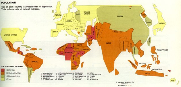
The above map has a different scaling then more familiar maps; Usually the area is used as scale, but in on this map the size of population of each country is used as a scale. You can compare the proportion between the areas India and the African continent take on this map and there proportion on regular maps. In our discussion this is a valid map of earth (if we remember the adjacent sides). The variety of possible scalings is true for configuration spaces as well. Since we can not scale the movement of the machine (we do not have any knowledge of the machine velocities in various states, nor do we expect to measure it). For example, here is another valid map for the configuration space of the one leg machine. Notice that although the velocity of the point moving on the circle is not constant the map is valid:
We have seen various maps of earth both in scale and in shape. The variety enables us to point out different aspects of our planet, but when we wish to describe the configuration spaces of machines; this variety is not on our side. In the next page, we will find out what is common to all the maps of earth and in what way all mappings of the 1-leg machine's configuration space are unique.
![]()